


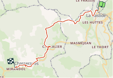
Stevenson 01 La Bastide - Mirandol

motardes04
User

Length
15.2 km

Max alt
1313 m

Uphill gradient
415 m
Km-Effort
20 km

Min alt
1024 m

Downhill gradient
341 m
Boucle
No
Creation date :
2015-08-21 00:00:00.0
Updated on :
2015-08-21 00:00:00.0
4h43
Difficulty : Very easy

FREE GPS app for hiking
 SityTrail
IGN / Geographical institutes
SityTrail Plus
The world is yours!
About
Trail Walking of 15.2 km to be discovered at Occitania, Lozère, La Bastide-Puylaurent. This trail is proposed by motardes04.
Description
Première étape avec Marie, temps de marche 4h43
Calcul Sity trail : 4h25
Calcul Topo : 12 km - 3h jusqu'à Chasseradès.
Positioning
Country:
France
Region :
Occitania
Department/Province :
Lozère
Municipality :
La Bastide-Puylaurent
Location:
Unknown
Start:(Dec)
Start:(UTM)
571806 ; 4938189 (31T) N.
Comments